From the Archive · Mining history
The Los Burros
Gold Rush
Gold, ambition, and isolation in the Santa Lucia Mountains
01 / A rush in difficult country
A Rush in Difficult Country
“Mines to bond all on the Famous Mother lode”: the promise appeared on a box-lid at a cabin, where horseback traveler J. Smeaton Chase stopped to read it. The advertisement offered quartz, placer ground, and mining opportunities in the Los Burros country. Chase copied it into the account published in his 1913 book, California Coast Trails. He was a later visitor, not a witness to the district’s original gold rush. Yet the notice provides a useful introduction to its history: a claim of opportunity, waiting for someone to take it up.1
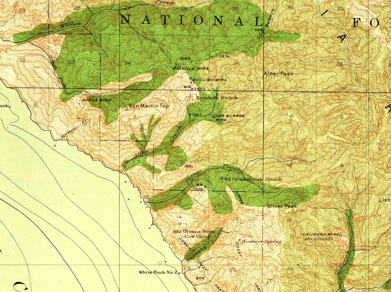
The setting was the western side of the Santa Lucia Mountains in southwestern Monterey County. When U.S. Geological Survey geologist James M. Hill visited in February 1921, he described rugged country where dense brush made movement away from the trails exceptionally difficult. Supplies and equipment had to reach prospects that were far less accessible than their distance from the coast might suggest.2
Gold prospecting had preceded the discovery most closely associated with Los Burros. Hill described Chinese miners washing river gravels near Jolon before 1887, while Hart’s later county report placed earlier prospecting in a broader Santa Lucia context. Jolon’s inland placer workings should not be mistaken for the Los Burros lode mines. Placer miners sought gold in sediment; lode miners followed mineral-bearing rock.3
The district’s organization also preceded the rush, although its date is disputed. Earl W. Hart’s 1966 report gives February 5, 1875, citing the district recorder’s Book A. Hill’s 1923 report gives 1876, citing an earlier state report. The underlying records have not resolved that difference. Hart names William T. Cruikshank as the recorder elected at the organizing meeting and describes many early claims as quicksilver prospects—quicksilver being mercury.4
A mining district and a gold discovery were therefore different events. Los Burros already had prospectors, named ground, and recorded claims before its best-known strike.
02 / The discovery and the rush
The Discovery and the Rush
The discovery that gave this earlier prospecting a new focus was W. D. Cruikshank’s small quartz vein containing free gold. Hart dates the find to April 7, 1887, and says Cruikshank named it Last Chance. Hill also credits Cruikshank with the discovery in 1887, but does not supply the precise day. April 7 belongs to Hart’s account, not to a date independently confirmed by both writers.5
Hart identifies Cruikshank as the district recorder’s son. In that account, the discovery linked two generations of the same family to Los Burros: William T. Cruikshank to its formal organization, and W. D. Cruikshank to the strike that brought renewed claim-making. The surviving descriptions establish the reported find, not a scene of its discovery. They do not tell us what Cruikshank said or how he first recognized its importance.5
What followed gives the find its significance. Gold in quartz called for a different undertaking from washing sediment. Miners had to break and process rock, then determine whether enough recoverable metal remained to justify following it underground. The first visible gold established a prospect; it did not establish the size or value of everything beneath it.
At Last Chance, however, the early work brought a practical return. Hill reported that gold recovered from the surface workings within four months paid for a three-stamp mill and a small boiler. A stamp mill crushed ore so that its gold could be recovered. The proceeds of the discovery were helping equip the mine.6
The claims followed quickly. Hart counted about 215 locations between April 1887 and August 1888 in the district records he summarized. Hill, looking back, characterized the excitement as limited by the rugged setting and difficult transport. One account measures claim-making; the other emphasizes the obstacles to turning it into a sustained industry.7
Names multiplied around the original discovery. By the time E. B. Preston’s county account appeared in the State Mineralogist’s report published in 1893, it listed Manchester, Last Chance, Queen, King, Charleston, and Grizzly among the properties being worked. But Preston found none operating continuously during his visit. Last Chance and Grizzly were the most active in development.8
Cruikshank’s find had helped turn a prospecting district into a place of named mines, equipment, and investment. Those activities were real, but a recorded claim was not necessarily a producing mine.
03 / Mining beyond easy reach
Mining Beyond Easy Reach
Preston’s report makes isolation an economic matter, not simply a picturesque feature of the landscape. Supplies came into the district by pack animals; difficult freight transport and limited processing facilities affected which ore was considered worth handling. He questioned whether the showing then available would attract substantial capital given the camp’s inaccessibility.
At Last Chance, he described redwood timbering in the workings and a mill equipped with a crusher and concentrator, powered by a twenty-horsepower engine. Rock had to be extracted and treated, and the installation maintained. The account follows mining beyond the discovery into the practical demands of operating it.9
The geology made that work uncertain. Hart described fractured and sheared rocks with small, discontinuous quartz veins. Following one promising section did not guarantee another. Hill likewise found the structure difficult to study beneath brush and accumulated soil. His observations belonged to a short reconnaissance, not a complete underground examination of the district.10
After Last Chance’s sale to the Buclimo Mining Company in 1908, Hart describes renewed shaft and tunnel work, including an ambitious drainage project. The enlarged workings did not translate directly into recorded output. When Hill visited in 1921, the underground workings were inaccessible to him.11
Even the diagrams have limits. Hart’s published reconstruction of the Buclimo workings drew on an unpublished 1910 engineering account, and he noted conflicting descriptions. It records how earlier workings were understood, not a survey of their present condition.
Taken together, the reports show equipment, labor, and engineering directed at a difficult deposit. They do not supply a complete account of costs or returns. Development was necessary to test the ground; it was not itself proof of a profitable mine.
04 / Mines, claims, and a reported town
Mines, Claims, and a Reported Town
The rush also has a community history, although its details survive less securely than the descriptions of the workings. Hart places the district’s peak activity between 1887 and 1892, when Manchester, also called Mansfield, flourished. He reports a population of 125–150 and lists a post office, two general stores, a restaurant, several saloons, and a dance hall.12
That list matters because it describes more than a collection of mine entrances. In Hart’s account, Manchester was a settlement with places for obtaining supplies, eating, exchanging mail, and gathering socially. The post office and stores point to connections beyond an individual property; the restaurant, saloons, and dance hall give the reported community a place in the story alongside the machinery and claims. They are documented details of Hart’s description, not permission to invent the people who used them.
Manchester’s significance is therefore not simply its reported size. It suggests how mining activity could sustain a concentration of services and social spaces in otherwise difficult country. Hart associates its flourishing with the years of greatest district activity. His brief account does not establish who ran its businesses, how many residents worked underground, or how households were organized. No imagined street scene is needed to recognize the community implied by the institutions he names.12
Hart reports that Manchester burned in 1892. That is a consequential event in his account, but the precise date, cause, extent, and subsequent rebuilding have not been independently established. Preston’s near-contemporary description of a Manchester mine confirms a property name, not the settlement’s population, institutions, or fire. Manchester remains part of this history on Hart’s authority, rather than through a separately corroborated town biography.12
The mines continued through changes of ownership. Hart records Last Chance’s sale in 1889 to a company headed by T. A. Bell, followed by further underground work. Cruikshank and J. M. Krenkel later leased it. In 1908 it was sold to Buclimo, whose name combined those of stockholders Burnham, Clinton, and Mory.13
Last Chance and Buclimo are thus not two independent discoveries to be counted separately. Nor does a group of associated claims mean that every named claim produced gold.
Placer activity brought another episode around the turn of the century. Hart’s account records Spruce Creek production beginning in 1901; Hill emphasizes nugget discoveries in 1902. These do not justify treating 1902 as the first occurrence of gold in the region. The Plaskett placer operations of that period must also be distinguished from the lode discoveries Hart dates to 1911 in F. M. Plaskett’s later claim group.14
Production figures require the same care. Hill estimated district output at $90,000. Hart’s compiled Bureau of Mines records, beginning only in 1889, listed 4,599 ounces of gold worth $104,471 and 494 ounces of silver worth $305. Their combined recorded value was $104,776. Hart separately estimated total district production at roughly $150,000 to allow for early and other unrecorded recovery.15
Those figures have different coverage and assumptions; they are not totals to add together. Nor are they profits. They establish real extraction without supplying a complete balance sheet—or measuring the whole life of the reported community.
05 / Chase arrives after the rush
Chase Arrives After the Rush
The records of claims and output tell us little about arriving in Los Burros as a stranger. Chase’s later journey changes the perspective: a traveler needed a route through the mountains and somewhere to stay, rather than an assessment of ore. In Chapter XIV of California Coast Trails, he describes descending to Los Burros and finding lodging with a German host and his family.16
That encounter brings an inhabited place into view. It does not prove that Manchester had survived or been rebuilt after the fire Hart reports. Chase names Los Burros; identifying his lodging with Manchester would require additional evidence. His account is valuable without making it resolve the settlement’s uncertain history.
The box-lid notice that opens this story belongs to the same later visit. It advertised mines, quartz that could be processed, placer ground, and the celebrated Mother lode. Chase recorded its irregular spelling and emphatic claims. For the traveler, mining promotion was something encountered beside the trail, not only in a company or geological report. He did not test the ore or verify the advertised ground: the notice shows an offer being made, not that it was sound.17
That distinction also applies to stories he heard along the coast. Near Pacific Valley, Chase recounts a gold-strike story associated with a ranch household. It is part of his narrative, but remains a reported story rather than an independently checked production record. His presence does not make every statement made to him firsthand evidence.18
Within those limits, Chase adds lodging, a family encounter, and a cabin advertisement to the district’s record. People were living in and moving through this country after the first rush. His observations give that continuing life a human presence without supplying the missing history of every mine or household.
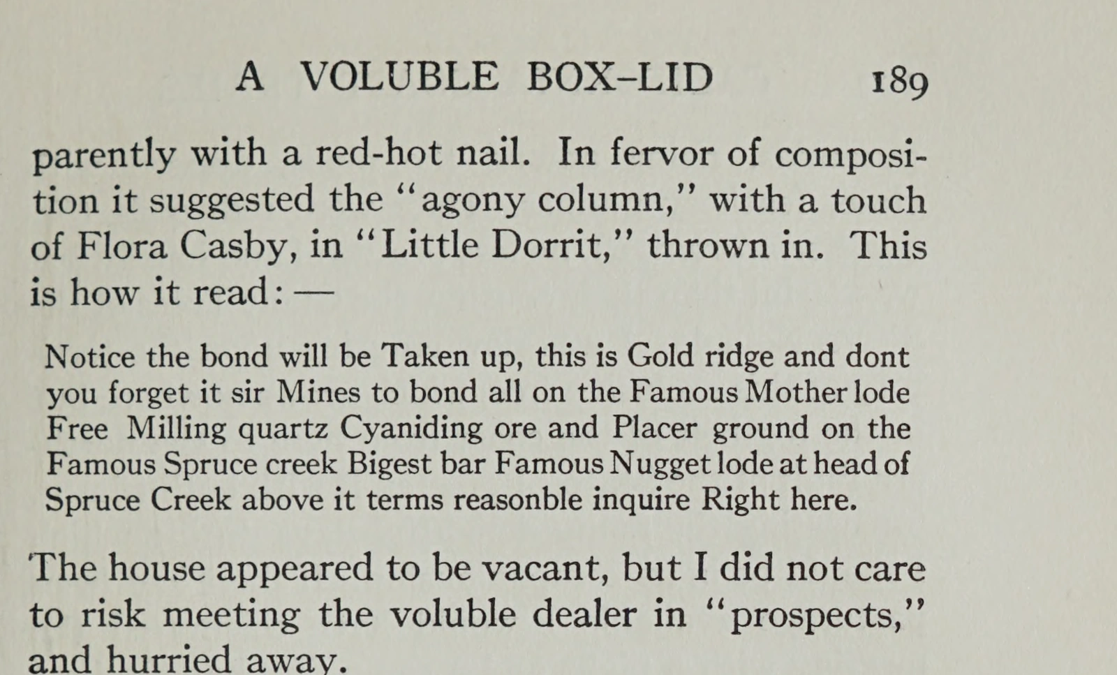
Notice transcription · original spelling and line breaks
Notice the bond will be Taken up, this is Gold ridge and dont
you forget it sir Mines to bond all on the Famous Mother lode
Free Milling quartz Cyaniding ore and Placer ground on the
Famous Spruce creek Bigest bar Famous Nugget lode at head of
Spruce Creek above it terms reasonble inquire Right here.
The notice documents promotion; it is not evidence that its geological or commercial claims were true.
06 / What the records leave us
What the Records Leave Us
Los Burros did not end in a single, well-documented moment of abandonment. Hart reports further intermittent work long after the nineteenth-century rush, including activity at Last Chance into 1941 and work in the Plaskett lode group through 1950. Later attempts belonged to the district’s history even when their returns were limited.19
In 1958, Gerald Doyle and James Pauley leased the Ancona mine, formerly called Brewery, and reopened its caved workings. Hart describes a selected sample with a high assay—a measurement of metal content—but a subsequent milling test on five tons of ore yielded much less recoverable gold. He reports that the result was unprofitable and the lease was abandoned in early 1959. The selected sample and the processing test were not equivalent measures of the mine’s value. This later episode returns the story to a recurring distinction: finding promising material and making it pay were different tasks.19
That longer chronology changes the familiar rise-and-fall outline. Discovery did not ensure continuous success; a pause in work did not mean no one would return. Companies, leases, prospecting, and small recoveries continued to produce a record that was uneven rather than neatly closed.
Today, Silver Peak Wilderness provides a different frame for understanding this part of the Santa Lucia Mountains. Congress designated the wilderness in 1992 and added lands in 2002. The historical Los Burros Mining District and the modern wilderness are not interchangeable geographical units; the names alone do not establish that every mine discussed here lies within the present boundary.20
Explore Silver Peak Wilderness
Historical maps and mine reports can illuminate that earlier use of the landscape without becoming instructions for visiting fragile sites or entering workings. They cannot establish present access rights or safe conditions.
The strongest account of Los Burros therefore keeps both achievement and uncertainty in view. Gold was found, mines were worked, and a settlement was reported. The available sources do not support every later legend or resolve every date. Chase’s advertisement remains a fitting starting point—but the district’s history rests on what can be established beyond the promise.
Research record
Endnotes
Page references below are printed folios, not PDF positions, OCR lines, or scan-leaf numbers.
- 1.J. Smeaton Chase, California Coast Trails (Boston and New York: Houghton Mifflin, 1913), Chapter XIV, pp. 188–189, especially p. 189. The advertisement excerpt was checked visually against the original printed p. 189 for the first draft. The full-resolution page acquired from the Boston Public Library verifies “Mother lode” with a space and no hyphen, and the excerpt here uses that verified reading. It preserves the advertisement’s capitalization and introduces no punctuation within the quotation. The box-lid context starts on p. 188 and continues onto p. 189. Original printed p. 189↩
- 2.James M. Hill, “The Los Burros District, Monterey County, California,” USGS Bulletin 735-J (1923), p. 323. Hill dates his brief field visit to February 1921. No current access directions are reproduced.↩
- 3.Hill, pp. 325–326; Earl W. Hart, Mines and Mineral Resources of Monterey County, California, County Report 5 (1966), p. 44; E. B. Preston, Monterey County account, Eleventh Report of the State Mineralogist, published 1893, p. 260. Hart’s earlier regional history cites antecedents, including Trask and Whitney, that were not independently reverified. The Jolon material is not treated as a Los Burros discovery record.↩
- 4.Hart, p. 44 and its Book A footnote; Hill, p. 325 and its reference to Irelan’s 1888 report, pp. 405–410. The recorder entry and Irelan’s relevant original pages remain uninspected. No separate 1876 reorganization is inferred.↩
- 5.Hart, p. 44; Hill, pp. 325–326. Hart supplies April 7, describes a small quartz vein containing free gold, names Last Chance, and identifies W. D. Cruikshank as recorder William T. Cruikshank’s son. Hill supplies the year and discoverer, not the precise day. Hart’s p. 44 was rechecked for this revision. The relationship is attributed to Hart, not independently established by genealogical records. The two authors’ agreement is not counted as wholly independent corroboration. No discovery scene, speech, or motive is reconstructed.↩↩
- 6.Hill, p. 325, continuing onto p. 326. Hill reports that the early surface recovery paid for a three-stamp mill and boiler. The draft does not invent the workings’ daily operation or the operators’ motives.↩
- 7.Hart, p. 44; Hill, p. 325. The approximately 215 claim locations cover April 1887 to August 1888 in Hart’s summary. His counts are not independently checked recorder entries, and the later 1891–1900 record gap is not evidence of zero activity.↩
- 8.Preston, pp. 260–262, especially p. 260. Charleston is identified there as formerly Grand Pacific. The report’s period ended September 15, 1892; its publication date is 1893. Publication year is not automatically the year of each observation.↩
- 9.Preston, pp. 259–262, especially pp. 260–262 for pack transport, freight constraints, processing, and the assessment of investment prospects. Hill, p. 323, supplies a later account of difficult access. Numerical freight rates and route instructions are omitted.↩
- 10.Hart, p. 44 and pp. 47–49; Hill, pp. 324–325. Geological descriptions are those of the historical reports, not new field observations or estimates of remaining ore.↩
- 11.Hart, pp. 46–48, including Figure 8 on p. 48 and the discussion of conflicting engineering descriptions on p. 47; Hill, pp. 326, 328. Hart’s cited 1910 Dockweiler/Gilman report remains an uninspected underlying source. The published reconstruction is not represented as a modern survey.↩
- 12.Hart, p. 44; Preston, pp. 260–261. Hart’s p. 44 was rechecked for the expanded Manchester passage. Manchester/Mansfield nomenclature, the 1887–1892 period, population, institutions, and the 1892 fire remain his retrospective account. The discussion of community significance interprets his listed institutions; it does not add named residents, businesses, scenes, household arrangements, or independently verified daily activities. Independent census, postal, institutional, and fire corroboration remains outstanding. Preston’s Manchester property does not establish all town claims.↩↩↩
- 13.Hart, p. 46. The account describes the 1889 sale, subsequent leasing by Cruikshank and Krenkel, and the 1908 Buclimo sale and name derivation. Portions of Hart’s early mine history depend on the unpublished 1910 account; those antecedents were not newly inspected.↩
- 14.Hart, pp. 51–52, and Figure 9 on p. 50; Hill, pp. 326, 328–329. Hart records Spruce Creek production from 1901 and Plaskett lode discoveries from 1911. Early Plaskett details partly cite C. H. Davis’s 1912 article, whose original remains uninspected. No placer/lode alias is silently collapsed.↩
- 15.Hill, p. 326; Hart, p. 44. Hart says the Bureau of Mines records date back only to 1889. The arithmetic $104,471 + $305 = $104,776 is a combined recorded value, not gold alone. Another compilation, State Mineralogist Report XV, issued with a December 1917 report date and a 1919 printing imprint, p. 603, estimates more than $150,000 for 1888–1915. These differing bases are not reconciled or added. Original production ledgers were not inspected.↩
- 16.Chase, Chapter XIV, p. 188. The host’s nationality and lodging are Chase’s descriptions. No invented family relationship, dialogue, or identification with Manchester is supplied. The transition contrasts the traveler’s perspective with mining reports; it does not supply a new eyewitness account of the original rush.↩
- 17.Chase, Chapter XIV, pp. 188–189. The advertisement is promotional evidence. The paragraph’s other advertising terms are paraphrases, not additional direct quotations. No exact journey year is asserted.↩
- 18.Chase, Chapter XIV, pp. 191–193. The Pacific Valley account is treated as a story reported by Chase, not verified production or firsthand observation of the discovery. Chase’s original edition and the Ventana Wilderness Alliance transcription are one source, not independent witnesses.↩
- 19.Hart, pp. 46–47, 51. The Ancona episode is on p. 46 and relies partly on Doyle’s 1963 personal communication, not independently inspected here. Later reported work does not establish continuous production. Hart’s 1959 condition observations are not extended to the present.↩↩
- 20.Public Law 102-301, §2(7), June 19, 1992; Public Law 107-370, §2(b), December 19, 2002. These support designation and additions, not an asserted correspondence between mining-district and wilderness boundaries.↩
Sources and Further Reading
- Earl W. Hart (1966), Mines and Mineral Resources of Monterey County, California, County Report 5, pp. 44–52. The main retrospective district and mine inventory; separates compiled production records from estimates and includes later observations. Its earlier historical assertions retain their source dependencies. Original scan access
- James M. Hill (1923), The Los Burros District, Monterey County, California, USGS Bulletin 735-J, pp. 323–329. A geological and mining account based on a few days’ reconnaissance in February 1921; not an inspection of every underground working. Original USGS report
- E. B. Preston, Monterey County account in the Eleventh Report of the State Mineralogist (published 1893), pp. 259–262. A near-contemporary description of named mines, development, and transport constraints. The title’s reporting period ends in 1892. Original volume
- J. Smeaton Chase (1913), California Coast Trails, Chapter XIV, pp. 182–193. A traveler’s observations, a transcribed advertisement, and reported anecdotes; directly relevant Los Burros passage on pp. 188–189. Original edition · VWA access transcription
- Barkle Collection, Series I, Monterey Public Library California History Room Archives. The institutional finding aid identifies Max Fischer’s 1889 district photographs, but does not identify individual subjects or clear reproduction rights. Collection guide
- USGS, Cape San Martin historical topographic sheet, 1921 edition, surveyed 1917, identifier 297003. Regional map candidate, not assumed to be the source of the existing History crop. No map file was acquired for either draft. Official sheet reference
- Wilderness legislation. Public Law 102-301, §2(7), and Public Law 107-370, §2(b), supply the modern designation chronology. Public Law 102-301 · Public Law 107-370